I know addresses in Ireland are a bit complicated and inconsistent: 40% of addresses are non unique. There’s a good description of the complexities on the AutoAddress site.
However, Google seems to be making things worse themselves.
1. Help, my baby is due and I need to get to ‘Saint James’ (part of Phoenix Park)’!
Google Maps generally includes a neighbourhood name in the address. For example, the UCD Library address is shown as “University College Dublin, Belfield, Dublin 4” while the Eircode website, which is about the nearest thing we have to an “official” address database, gives the address as “University College Dublin, Stillorgan Road, Dublin 4”. I imagine that someone in Google decided that it would be a good idea to include neighbourhood names to aid navigation and give a bit of local favour. This would be a nice idea except that there are no official divisions which are widely understood by Dublin residents or used on regular city maps.

I doubt there is widespread agreement what “neighbourhood” the Coombe Hospital is in. If you ask locals, they’ll probably say Dolphin’s Barn or just Cork Street. I am however sure that no-one will say “St James'”, never mind “Saint James’ (part of Phoenix Park)”. The same is true of most places in inner city Dublin.
I know the lack of officially agreed neighbourhoods may not suit Google’s standards but inventing their own only creates issues.
2. My townland is under concrete!
A related problem exists outside Dublin and Cork cities. Google seems to include townland names in the address, even in urban areas where the fields which comprised the townland have long since disappeared under concrete and brick and the townland name removed from official maps, if they ever existed.
For example, according to the Eircode database, the Wexford Opera House is at High Street, Wexford, Y35 FEP3. Google maps gives this as High St, Ferrybank South, Wexford, Y35 FEP3. As far as I can tell from OpenStreetMap.org, Ferrybank South is a townland about 1.5km away across the Slaney.
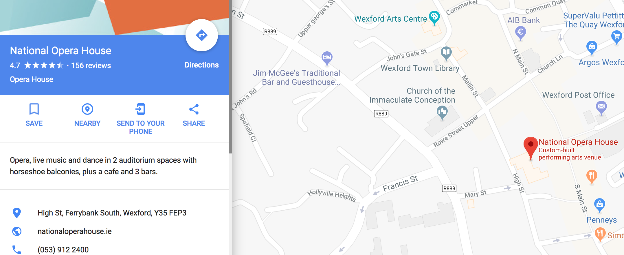
It seems that someone is Google has decided that addresses outside the big cities must include a townland name. For rural addresses this is correct. However Wexford town, being urbanised since the 10th century, does not have townlands. Google seem to have dealt with this by including the nearest one…
3. Google’s half-hearted snog with Eircode
Eircode is Ireland’s “postcode” system which was launched in 2015. Unlike other postcode system, each address has a unique Eircode. Google maps has supported Eircode since late in 2016. Most (not all) addresses seem to include the Eircode and if you type in an Eircode, the map centres on the appropriate building.
The latter feature has not been properly integrated as the specific address information is not presented back. So if you type in “D08 XW7X”, which is the Eircode for the Coombe Hospital, the pin is located correctly but the address displayed is simply “Saint James’ (part of Phoenix Park)”. Of course, as described in issue 1, this “neighbourhood” is meaningless. Furthermore the Streetview image often does not match the address.

This has a direct effect on websites and apps which use Google Apps, for example Deliveroo. So if you search for D04 E5W5 on Deliveroo, it helpfully suggests the location is “Dublin”! If you search on Four Star Pizza, which does not use Google Maps, it gives a lot more information.

If Google staff in Dublin need a pizza delivered in a hurry they should avoid apps which use Google Maps! As more apps which use Google maps become popular, these issues are sure to affect more and more people.
Google don’t make it easy to send feedback about their maps. There are options to report a specific issue but not to report a systemic issue. So unless we can get people to report about 800,000 addresses, I’m not sure how this can be fixed.
In the interim, I really hope the emergency services are not depending on Google map data.

And then there’s “Townspark”. I first noticed it with Birr, Co Offaly. But Google uses it all over Ireland, and some journalists are including it in addresses of places they report from.
LikeLike
That’s interesting – I wasn’t aware of “Townparks” before. I found this helpful article on Wikipedia:
https://en.wikipedia.org/wiki/Townpark. It’s a particularly strong example of the absurdity of Google’s inclusion of townland names in urban areas.
LikeLike